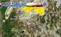
After several days of poor air quality from the Mosquito Fire, Reno’s air quality will be much better on Sunday. An area of low pressure will drop into northern California Saturday night, and give the region a chance for rain through Wednesday. The majority of the rain will fall along the western side of the Sierra, but some light to moderate rain will fall in the valley too. A change in wind direction will also help to clear the air. Places like Stead, Cold Springs, and the North Valleys could still see some haze Sunday, but the air quality will be much better in the majority of the region, including around Lake Tahoe. Enough rain will fall over the Mosquito Fire to help fire fighting efforts, but it won’t be enough to put it out completely.

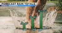
The models are not completely in agreement with the timing of the low or how much rain will fall, but they do agree that a strong low will slip south along the California coastline by Sunday morning and eventually lift to the northeast by Wednesday evening. A mid latitude cyclone spins counter clockwise and produces what’s called vorticity or spin in the atmosphere. The best place to see rain or snow is usually in front of the low, where vorticity advection is maximized. While the low will be to the west of the Truckee Meadows Sunday, the mountains will keep the majority of the rain from reaching the valley because of shadowing. As the low gets cut off from the jet stream and travels south, the valley will have a better chance for seeing rain by late Monday into Tuesday. Rain totals will be much higher in the Sierra compared to the valley. Rain totals will range from .50-1.25” in the mountains, to .10-.25” in the valley Sunday through Wednesday. The rain won’t be heavy each day, but will add up over time. It will also be cold enough for snow to fall above 7000’ beginning early Monday and going through Wednesday. Roads like Mt. Rose Highway could see some slushy accumulations, but impacts will be minimal because of the recent warmth.

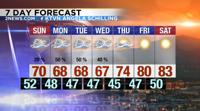
Highs on Sunday will only be in the upper 60’s. Tack on the wind and it will feel even cooler. This is about fifteen degrees below average for this time of year. It will be cool in the morning as well, with temperatures in the 40’s. The cooler air and added moisture will certainly help with fire fighting efforts. The strength of the fire is the number one factor in our smoke forecast. After a work week filled with highs in the upper 60’s, next weekend will be mild with highs in the low 80’s.

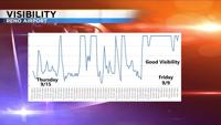
The rain will be good for our drought situation, but more than anything it will be nice to breath clean air again. The smoke can act like fog, lowering visibility. The chart below shows visibility trends from Friday September 9th through Thursday September 15th. The smoke seemed to break a part each day during the late morning, and worsen after sunset. This trend correlates with visibility data. Beginning Sunday, Reno will see more cloud cover than smoke and haze. Each model has many ensemble members. The ensembles are showing a wide variety of rain totals in the valley, ranging from a tenth of an inch to over an inch. The vast majority of ensemble members shows between a tenth of an inch and a third of an inch. The Truckee Meadows is still in a severe drought. Follow me on Facebook at KTVN Angela Schilling and Twitter at Angela Schilling for more weather updates. You can also follow me on Instagram at Angela Schilling. Enjoy the rain and cleaner air.

[ad_2]
Originally Appeared Here
